
Up at seven! We’re ambitious today and want to both walk and visit a castle, so we try to be a bit more efficient with our morning routine. For the walk, last week I investigated the sights, the paths and parking options and came up with a tour of about 12 km. The parking is just a bit of gravel off the road, safe enough but definitely not popular. It looks like this is a quieter bit of forest than yesterday.
We’re starting with the easy, boring bit and follow the tiny Kall river to the village of Simonskall. It’s a wide gravel road, with one side the burbling water and on the other a steep, forested slope. This whole area is dotted with bunkers, it’s part of the Siegfried-line (in German: Westwalle) of the second World War. Today’s goal is to see some of these bunkers as well as memorials, and I’ve made the route especially to pass by as many as possible.
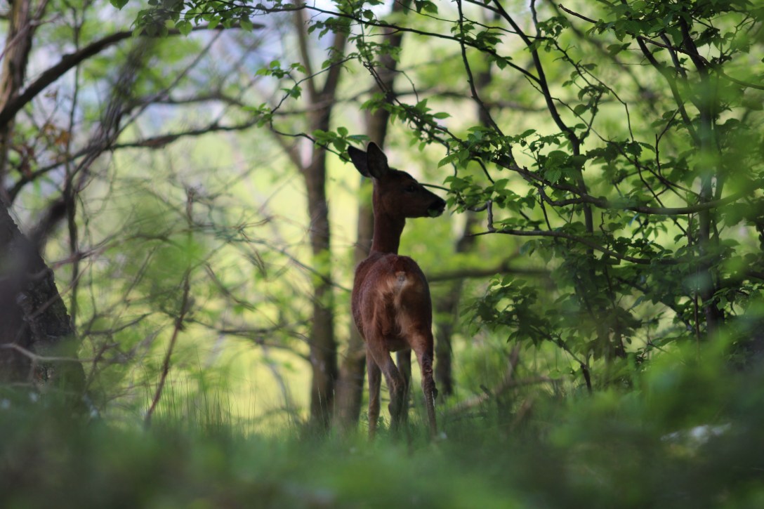
This complex of valleys and hilltops is a bit unusual in the sense that villages, roads and fields are all on top, whereas the valleys remain forested, because they’re mostly to steep to cultivate. Often you can see the bedrock sticking out of the forest, as if the trees and plants form only a thin layer on top. One suck outcrop sticks out and makes a pretty viewpoint over the valley, at least if you can find a gap in the trees. We spot a roe deer (Capreolus capreolus) foraging close by, it spots us as well but doesn’t seem alarmed when we tiptoe along the foot path to have a better look at it. It eats some leaves of a tree, stares at us a bit and then moves on.


Nearing Simonskall, the map shows us the first bunker is somewhere nearby. It’s really difficult to spot, then we simply follow the small trail leading away and run straight into it. It’s dug in and must have some intact rooms inside, because the openings are barred and there’s a sign admonishing us to leave the bats alone. We back away carefully and continue on. Simonskall village comes as a bit of a surprise: we encounter more hikers, a slow worm (Anguis fragilis) on the road, see a few hotels and even a tourist office. We don’t want any of the business, so we pass through quickly and go up the hillside on the other side of the Kall river. It’s quite a climb, but there’s beautiful views at the top. We turn west to start our way back towards the car. The road is gravel again, a bit boring, but then we’re not (entirely) here for the charm of the environment. We encounter one bunker after the other, some well preserved, some in pieces. Wikipedia tells us the unhappy details: the battle of Hürtgenwald preceded the battle of the Bulge in the Ardennes (quite nearby) and was the longest battle on German ground, as well as the longest single battle the U.S. Army has ever fought. They were driven back into the Ardennes after three months, with heavy losses. The enormity of war, with its logistics, strategies and planning, as well the personal side of it are mind blowing. An example of such a personal story is the memorial to a U.S soldier we encounter: Robert Cahow went missing in action since 1944, his remains recovered during a mine sweep in 2000 and brought back to his family. Aside of the memorial, a cairn with flags and pictures remains to indicate where he was found, even after the forest around it was logged.
Lunch time has passed, but we seem to have missed the opportunity somehow.. bad planning. We have plenty of water, but we forgot to take our Kitkat snacks and figured we’d be done walking before we got too hungry. As a result, we’ve walked on for eight kilometres without a break and we’re feeling the need for a sit down. No benches around here, but there are plenty of suitable tree trunks to serve as a bench where we can rest our feet. About four kilometres left to go, I think. We’re at about 500 m now, so it’s downhill all the way to the car. We reach the head of some small tributaries of the Kall and follow the growing brook down to the bridge where we’ve parked. It’s about two when we arrive, it feels great to take off the walking shoes and compression socks.


Next stop is Nideggen, a small town with a medieval castle. We can see it looming as we arrive, on a rocky promontory high above the valley. We’re into tourist country again, so it’s a bit harder to find a parking space. We walk up to the old town, have a piece of pie (for lunch? dessert?) and then explore the castle. The museum doesn’t interest us that much (we’ve seen a few already about medieval life and castles), but we like the view from the battlements. We search and find the back way to the car, avoiding the town entirely, following narrow foot paths through the forest. We’re still only early afternoon, so we decide to stop at Schloss Burgau near Düren, more or less on the way. A charming castle surrounded by a moat, in the middle of a large, green park. We walk around it – the shortest way possible to spare our tired feet – and decide it’s been enough for the day. Back to the hotel, sort the pictures, shower, out for dinner in the Italian restaurant across the street, where I write the daily report. I’m running out of books, again! The hotel wifi sucks, but it’ll hopefully hold through another search, buy and download.
